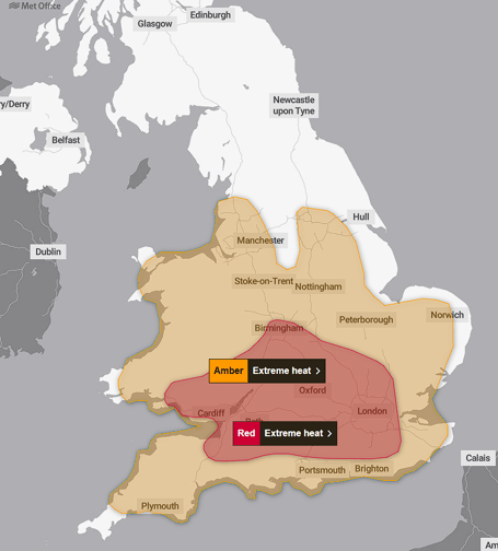
The Met Office has issued a Red Extreme Heat Warning for Wednesday, June 24 and Thursday, June 25 this week, with temperatures across Surrey and Hampshire forecast to break June records dating back nearly 70 years.
The red warning has been issued alongside previous Amber heat warnings covering much of southern England from Monday through to the end of Thursday.
Temperatures are expected to reach 34°C across southern England today before climbing to 37°C on Tuesday. The peak of the heatwave is forecast for Wednesday and Thursday, when highs of at least 39°C are anticipated with the possibility of even higher readings in some areas.
The current UK June temperature record of 35.6°C, set in Southampton in 1976 and the Met Office suggest this is likely to be broken.


Met Office Deputy Chief Forecaster Mark Sidaway said the heat would be accompanied by unusually high humidity, making conditions particularly oppressive. He warned that health impacts were likely for many people, not just those normally considered vulnerable.
Overnight temperatures will also remain exceptionally high, with widespread tropical nights forecast where the mercury stays above 20°C making it difficult for people to recover from the daytime heat.
Authorities are also warning of increased risk at open water sites, as more people are likely to head to rivers, lakes and the coast to cool down. The RNLI is reminding people that sea temperatures remain cold enough to cause cold water shock, and is advising swimmers to choose lifeguarded beaches and remember the Float to Live technique if they get into difficulty.
Comments
This article has no comments yet. Be the first to leave a comment.